Haiti does not lack data institutions. It has a national geospatial center, a statistics institute, a territorial planning committee, an environmental information system, and a civil disaster protection map. What it lacks is having these tools working as an integrated system in service of the local governments that needs them most. Visit their websites today and you will find blank pages, broken links, and a phrase that has become the quiet verdict on the Haitian state’s relationship with its own territory: « En attente. » What it lacks is not the institutions. It is having them work
Decentralization and development are the two words that have defined Haitian political ambition for nearly four decades. Governments have come and gone, invoking both. But decentralization is a system that requires elected officials who have the legal authority to govern, the fiscal resources to act, and the information to decide. Remove any one of those three, and the rest collapses. Haiti has spent thirty years arguing about the first two. The third, data, and the basic knowledge of what exists in a commune’s territory have been treated as secondary, a technical detail, and something that will sort itself out. The crumbling infrastructure, the lack of local planning, and the limited development have demonstrated that it has not sorted itself out.
Why data as a local governance tool?
The absence of geographic and statistical, along with demographic and socioeconomic, data is not an administrative inconvenience. It is a structural reason why decentralization has never worked, why development plans are written and forgotten, and why local governments across Haiti are making decisions that affect hundreds of thousands of people using nothing more reliable than memory and assumption.
Geographic Information Systems, or GIS, together with socioeconomic and territorial data, are at their core a way of asking and answering spatial questions. Where do people live? How many people live in a specific area? Where are the roads, the schools, and the water sources, and who uses them? Where does the land flood, erode, and slide? Where is the agricultural land, and who farms it? What does this commune’s territory actually look like, measured and mapped, rather than described from memory? In a functioning state where local governments have real planning authority, these questions have answers. In Haiti’s communes, they do not.
This is not a theoretical claim, as regional actors have shown that the implementation of such tools is efficient. Colombia’s Law 388 of 1997, building on its 1991 constitutional decentralization, made the Plan de Ordenamiento Territorial, a mandatory cartographic and spatial planning document produced with geographic data from IGAC, Colombia’s national geographic institute, a legal requirement for every municipality, directly linking territorial data production to local planning authority. The parallel with Haiti is exact: Colombia’s 1991 constitution devolved authority to municipalities the way Haiti’s 1987 constitution devolved authority to communes, on paper, with genuine intent, and with incomplete follow-through. Colombia built the informational infrastructure to make that devolution real. Haiti has not. That institutional decision produced municipal officials who govern with evidence and can hold the central government accountable because they have the data to do so. Haiti made the opposite decision, consistently, across every government for the past three decades. What that choice looks like in practice is what the rest of this paper documents.
This argument is as much a governance argument as a technical argument. Data is an essential tool of politics. It is an instrument that makes local politics functional rather than performative. Without it, a local government official cannot know whether a desired road to be built serves fifty families or five hundred. They are unable to know whether the school being requested is needed because the population has grown or because three other schools in neighboring sections have closed. They are unable to accurately demonstrate to the Ministry of Planning that a commune has been systematically underinvested relative to its population because the population figures needed to make the comparison are unavailable. Thus, many local government officials govern by feel, pressure, what is visible, and whom the loudest are, which is the environment in which patronage networks thrive and genuine development planning dies.
This is why the failure of Haiti’s data institutions is not a secondary story about bureaucratic dysfunction. It is one of the primary reasons why the constitutional architecture of local governance has never been fully activated, alongside the absence of clear funding mechanisms, the lack of capacity building at the local level, and the persistence of centralized political control. A commune without data can argue, plan, or account only within the limits of what can be observed. The institutions designed to provide more than that have remained largely inaccessible for decades. Some have existed in name. Few have functioned in practice. And through it all, every government has continued to announce its commitment to decentralization. The gap between that announcement and that reality has never been closed.
What exists, and what does not work
Haiti does not lack data institutions. It has a national geospatial center, a statistics institute, a territorial planning committee, an environmental information system, and a civil disaster protection map. What it lacks is having these tools working as an integrated system in service of the local governments that needs them most. Visit their websites today and you will find blank pages, broken links, and a phrase that has become the quiet verdict on the Haitian state’s relationship with its own territory: « En attente. » What it lacks is not the institutions. It is having them work.
The institutions and what they were built to do
The following institutions are pieces of what could be a unified state infrastructure for territorial and local governance. And understanding what is broken requires seeing them as such. The National Center for Geospatial Information (CNIGS), the Interministerial Committee for Territorial Planning (CIAT), the Haitian Institute of Statistics and Information Technology (IHSI), the Recovery Observatory (RO), although temporary; the Environmental Information System (SIE-Haïti), and the Protection Civile map were each built to answer a specific question.
CNIGS was created to know where things are: the administrative boundaries, the communal sections, and the land. IHSI was created to manage demographic and socioeconomic data, population, labor force, poverty rates, and more. CIAT was created to translate these data into coordinated territorial policies. CIAT’s mandate extends further than a single coordination role. It includes a regional planning authority, the Autorité Régionale d’Aménagement du Territoire (ARAT), created by decree in 2017, that should be present in each administrative region and is explicitly designed to include local officials in territorial planning decisions. It includes an economic development unit mandated to provide technical support to territorial collectivities. However, beyond the descriptions on the website, there is no published plan, no documented activation, no record of output, and no evidence that any commune has ever been served by any of it. SIE-Haïti was created to track the state of the environment, deforestation, watersheds, and biodiversity. The Protection Civile map was created as the planning, risk, and resilience infrastructure for disaster management. Together, if they worked and talked to each other, a local government official would have the baseline information needed to plan infrastructure, justify a budget, prioritize a road construction, etc. Without them, what remains is administration by observation, by political pressure, by precedent, and by whatever local officials feel is important.
The data failure is not simply the absence or inactivity of any single tool, but also the absence of an accessible integrated system makes leading local governments more challenging and less efficient. Environmental data without population data cannot accurately tell you which watershed a growing community depends on. Population data without land maps is unable to clearly point to where to build. Land maps without risk data cannot tell you where not to build. Disaster risk data without development planning data cannot tell you what assets are in danger. Each layer makes the others meaningful. None of them, alone, is enough.
What the 2025-2026 Public Investment Program Shows
The adopted 2025-2026 Public Investment Program, the PIP, published by the Ministry of Planning does show that the state has not entirely abandoned investment in this infrastructure. CNIGS appears in the budget with 85 million gourdes allocated. IHSI receives 100 million. The Ministry of Planning’s own territorial development program carries 2.5 billion gourdes. The Ministry of Interior’s decentralization program lists commune-by-commune funds under a territorial development and planning fund. There is a 15 million gourde line for a communal information system for sustainable governance in specific communes. There is, in the budget, at least the vocabulary of local investment.
In looking more carefully at what these allocations actually do, one can observe that the CNIGS budget funds the institution’s existence, not its mandate to serve local governments. There is no line for tools that help communes, no training programs, and no way for local governments to access CNIGS’s holdings. IHSI’s 100 million gourdes does not appear to include a new census or even a commune-level population update. The MICT territorial funds are routed through a central ministry to departmental offices, not to communes themselves, and they are for the construction of administrative buildings, not for planning capacity or data access. The communal information system line at 15 million gourdes is a single budget entry, with no published methodology, no implementation plan, and no evidence that Haiti’s National Federation of Haitian Mayors (FENAMH) or any commune was consulted about what that system should contain or how it would work in practice.
This is the deeper problem the PIP reveals. The program is titled “Programme de Modernisation de l’Administration Centrale”, Modernization of the Central Administration. The word “centrale” is doing the work. These investments are being designed in Port-au-Prince by ministry planning units in Port-au-Prince through a consultation process that mainly convened the Unités d’Études et de Programmation of sectoral ministries and not FENAMH. The Ministry of Planning described the PIP’s purpose as “transforming national priorities into projects.” The investment in local territories appears to be real, but the logic of these investments flows entirely downward from the center. Local governments are the destination of these projects, not the authors of them.
Tools simply designed for the central government
The budget makes that distinction visible. It matters not because central investment is wrong but because investment that does not include local government in its design will not reach them in practice. A secure satellite communication network funded at approximately 1.5 billion gourdes in the PIP’s budget goes to the Ouest department, a legitimate infrastructure investment. But CNIGS’s budget includes no mechanism for a mayor in Dondon to query what that network produces. SIE-Haïti, with recent environmental data, has no documented outreach program and no training protocol for local government officials. The Protection Civile map, one of the most functional tools available, was built for emergency response coordinators, not for mayors doing five-year infrastructure planning. The tools are real, but the gap is in who they were designed to serve. What the government has built, in other words, is a set of tools designed for itself, for central ministry officials, for international partners, and for national planners that happen to contain information about local territories.
Haiti’s geospatial infrastructure has been rebuilt more than once. The Service de Géodésie et de Cartographie (SGC), created in 1955, fell dormant for decades. In 1998 a new unit was created, the UTSIG, which by 2002 had produced a national land use map and erosion risk maps. In 2005, UTSIG was merged with the revived cartography service to create CNIGS. Then came the Recovery Observatory in 2016, co-chaired by CNIGS itself. It closed in 2020 without a succession plan. Each time, capacity was rebuilt under a new name rather than maintained under the existing one. Each time local governments remained outside the loop.
Every data tool Haiti currently has reflects who those who commissioned their design imagined as the end-user. A ministry official in Port-au-Prince. An international partner. A national planner. Their inaccessibility to local governments is a design assumption that appears never to have been questioned. A tool designed for national use will organize its data at the national level, require technical literacy that commune officials do not have, present its findings in formats that make sense to a Port-au-Prince planner and no sense to a mayor in Chantal or Cerca-la-Source, and never include the commune as a feedback loop in its own design. It will perpetuate exactly the relationship it was built within: the center knows; the periphery receives.
The pattern is not accidental, and understanding why it persists requires asking who benefits from it. Central ministries control budget allocation, project design, and procurement. A commune with reliable population data, territorial maps, and fiscal baselines can do three things it currently cannot: demonstrate that central allocations are disproportionate to its population, audit whether PIP projects in its territory were completed, and argue with evidence for the tax revenues the constitution already guarantees it. Each of those capacities directly threatens the discretionary authority central ministries currently exercise. The incentive to keep communes data-poor is therefore structural. It does not require a deliberate decision to withhold anything. It only requires that the people who control data institution budgets have no compelling reason to redirect those institutions toward users who would use them to push back. The PIP consultation process is the clearest evidence of this: by the Ministry of Planning’s own governing circular, it runs through ministry-level program directors. Not local government officials. That is a documented institutional choice, not an oversight.
The CIAT decree of 2017 created regional planning authorities explicitly designed to include local governance in territorial decisions. There is no documented evidence any of them have ever convened.
The tools are not enough
Suppose, for a moment, that the tools described above were fixed tomorrow. CNIGS published updated maps of all the communes in Haiti and their communal sections. IHSI released updated socioeconomic and demographic data. SIE-Haïti integrated its environmental data with the Protection Civile risk maps and made everything available through a single portal. The Recovery Observatory came back online. Would Haiti’s local government be able to use any of it? The honest answer is no. Not without the one thing that precedes all of it: capacity.
However, capacity is an overused word in development policy, often deployed as a polite way of saying that poor countries do not know what they are doing. The meaning here is specific and institutional, and it translates as training local officials, equipping municipal offices, and giving communes the real access to turn data into decisions. A commune needs at least one staff member who can open a GIS file, read a population projection, interpret a risk map, and translate what it shows into a budget line or a planning document. It needs computers that work and an internet connection reliable enough to access an online portal. It needs the institutional authority to act on what the data shows, not just to receive information but to make decisions based on it without requiring approval from a central ministry for every step. And it needs the legal protection and the funding of knowing that the person who holds these skills will still be employed next year, regardless of who wins the next election.
None of these conditions currently exists in most Haitian communes and communal sections. Local government officials govern with extremely limited administrative capacity and often without a formal territorial civil service or sufficient technical staff. A small-town municipal council may have two or three employees whose primary responsibility is issuing civil documents, not analyzing data or writing planning reports. And beyond the structural barriers, there is a human one: insecurity and Haiti’s economic fragility have caused a brain drain, where qualified technical staff leave public institutions for the private sector and the diaspora. Many of the people who might have built local data capacity have, in many cases, already left.
What a minimum viable investment actually requires is not primarily a staffing question. It is a retention question, and retention is where every previous attempt at building local technical capacity has broken down. The Haitian civil service currently employs over 100,000 people at an average salary of approximately 37,000 gourdes per month. For a technically qualified officer, one with the technical skills to open a GIS file, read a population projection, and translate what it shows into a budget document, that figure is not competitive. The NGO sector, international organizations, and the private sector all offer salaries that local-level public administration cannot match, which is where qualified technical staff have gone. Placing professional data and planning officers into that same salary structure, without a protected civil service classification insulated from electoral turnover and a wage scale that reflects their qualification rather than administrative grade, would reproduce the same outcome. The positions would exist, and the people the institution needs to keep would not stay in them. Closing that gap requires a salary structure decision made at the national level and protected from reversal. This is a political commitment problem, and it is the reason the investment in data infrastructure and the investment in local capacity cannot be sequenced. They have to move together, or neither works.
Three tracks need to move simultaneously. The first is legal: CNIGS’s mandate must include a documented service obligation to communes, and commune officers must have legal standing to request data from national institutions, not as a courtesy but as an enforceable right. The second is technical: a single interoperability layer connecting CNIGS, IHSI, SIE-Haïti, and Protection Civile data into a commune-accessible portal. The marginal cost of this, if the integration work is done, is close to zero. The third is human: the positions with civil service protection written into enabling legislation. Without that protection, technical staff will turn over with every election.
The honest concession is that the first track requires political will, which recent governments have not demonstrated. Should it exist, the cost of acting on it would be remarkably low. The obstacle is not resources.
Data without capacity, capacity without data
The two investments are inseparable. Data without capacity produces information that only serves the central government. Capacity without data produces officials who govern blind. Together, they produce something Haiti has not yet had at the commune level: evidence-based local governance. Separately, they produce what Haiti has always had: the appearance of decentralization without its substance.
One honest qualification the investment argument requires is that Haiti’s communes are not a uniform target. Three realities currently coexist. In secondary cities such as Cap-Haïtien, Jacmel, Les Cayes, and Gonaïves, state administrative presence is meaningful enough that a data officer could be deployed today. In a larger group of communes, state presence is partial but not absent, and investment is possible with explicit security protocols and a likely NGO or UN partnership for initial phases. In a third group, like part of Ouest and sections of the Artibonite Department, gang control has displaced state administration, and the capacity argument, however correct in principle, cannot be operationalized in the short term. This reality converts the approach from an abstract national program into a sequenced, geographically realistic one. It also makes a point the data argument has not yet made explicitly: the communes that have lost state presence are the ones where the absence of territorial data is most acute. Knowing who is there, what infrastructure existed, and where people have moved is not a planning exercise for post-conflict reconstruction. It is the precondition for one.
What it costs not to invest
Conversation about investing in local government capacity in Haiti often runs into the same objection: Haiti has no money to fund these initiatives. The country is in its seventh consecutive year of economic contraction. The state collects tax revenues equal to under five percent of GDP. The PIP is already stretched between security, elections, and basic services. However, the fiscal question is not what it costs to invest in local data capacity. It is what it costs every year not to.
Start with the PIP itself. The program allocates 109.9 billion gourdes across Haiti’s territory. The Ministry of Planning has not published the demographic methodology behind its territorial allocations. What is documented is that Haiti’s last census was conducted in 2003, that IHSI’s most recent commune-level population estimates date to 2015, and that no updated governmental figures have been produced since. A public investment program designed without more current territorial data, and there is no public evidence that any exists, is a program allocating resources across a territory it cannot accurately measure. Administrative buildings are being constructed in communes whose populations may have doubled or halved since the last time anyone counted. When public investment is allocated on that basis, and without documented local government input, the structural conditions for misallocation are not occasional. They are permanent and compounding. Each budget cycle built on the last bad baseline moves further from the territory it is supposed to serve.
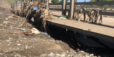
The disaster cost is direct and documented. Haiti experiences hurricanes, earthquakes, floods, and landslides with a regularity that makes disaster risk management not a contingency but a permanent feature of governance. When disaster strikes, local officials respond without updated population maps, without baseline infrastructure records, and with a limited documented picture of what existed before. The response defaults to the central government not because central coordination is more effective, but because it is where most of the information sits. The 2016 Hurricane Matthew assessment documented the cost of this gap: delayed needs assessments, duplicated interventions, and reconstruction funding that could not be targeted accurately because no one could establish a verified baseline. That delay is the direct consequence of a state that does not know its own territory before the disaster arrives, and it affects, in part, how much reconstruction funding Haiti receives and how fast it comes.
The revenue cost is structural. Under Haitian law, communes are legally entitled to a share of property taxes, business license fees, and rental income taxes collected on their territory. The patent alone represents the primary source of municipal own-source revenue. The central government remits these funds inconsistently. The Fund for the Management and Development of Territorial Collectivities (FGDCT) transfers budgeted for 2019-2020 had still not been paid to communes as of March 2021, according to FENAMAH. But the transfer gap is only half the problem. A commune that cannot map its commercial properties has no independent basis to verify whether its patent receipts reflect actual business activity on its territory. A commune without current population data cannot demonstrate that its allocation is disproportionate to its actual needs because it lacks the baseline to make the comparison. Data capacity is not separate from fiscal capacity. It is the precondition for it. A commune that knows its territory, its population, and what it is owed is a commune that can argue, with evidence, for the resources the constitution already guarantees it.
The return on changing that decision is the avoided cost of 109.9 billion gourdes allocated blindly. It is a faster, more accurate disaster response. It is the recovered revenue local governments are constitutionally owed but cannot claim. It is public spending that reaches the right places because someone, finally, measured where those places are and who lives in them. The investment required to produce that return, data officers in protected positions, an interoperability layer connecting institutions that already exist, and a mandate reform that costs nothing to decree are not large relative to what is already being spent. What is large is the cost of continuing not to make it.
Haiti has the data institutions and tools that could initiate the work toward sustainable development. The lack of access to data for Haiti’s local governments is a verifiable failure. The failure has been paid for by every Haitian who has ever voted, expecting something to change in their commune or communal section. Haitians deserve local governments that can act, that can plan, justify, and deliver. That cannot happen as long as the central government insists on holding everything, the data, the decisions, and the resources, while the communes it was supposed to empower are left waiting. The work of governing a commune cannot be done from Port-au-Prince. What it requires is sustained investment in the tools and specialists that can support local governments to carry that work forward, which will eventually lead to the decentralization and the development that has been in the collective consciousness for the last four decades. As Haitians wait on the central government to empower their voices through local government, the websites of the tools that can do so confirm what their answer has always been: « En attente. »
By : Ervens Jean-Pierre
Cover |A street scene in Delmas 32, a neighborhood in Haiti which many residence. Photo : World Bank Photo Collection
► AyiboPost is dedicated to providing accurate information. If you notice any mistake or error, please inform us at the following address : hey@ayibopost.com
Keep in touch with AyiboPost via:
► Our channel Telegram : Click here
►Notre Channel WhatsApp : Click here
►Our Community WhatsApp : Click here


Comments